


DJI Zenmuse L2 with Dronefly Care Plus: High-Precision LiDAR and RGB Mapping, Professionally Protected
The DJI Zenmuse L2 combines precision LiDAR scanning, a high-accuracy IMU, and a 4/3-inch RGB mapping camera into one stabilized payload for professional surveying and inspection missions. Designed for seamless integration with DJI's enterprise flight platforms, the L2 captures dense point clouds and true-color imagery in a single pass, reducing workflow time and maximizing data accuracy. Bundled with Dronefly Care Plus, this payload includes 13 months of extended protection against accidental damage and internal malfunctions-keeping your team's equipment secure and field-ready.
Integrated LiDAR Accuracy for Enterprise Workflows
The Zenmuse L2 delivers horizontal accuracy of approximately 5 cm and vertical accuracy near 4 cm under optimal survey conditions at 150 m altitude. The LiDAR system supports repetitive and non-repetitive scanning modes, enabling both structured mapping and terrain-penetrating analysis. Detection range extends up to 450 m at 50% reflectivity and 250 m at 10% reflectivity. The payload produces up to 240,000 points per second in single-return mode and up to 1,200,000 points per second in multiple-return mode. Its RGB camera, featuring a 4/3 CMOS sensor, provides detailed imagery for photogrammetry and colorized point clouds. IP54-rated protection and a 905 g build make it reliable for extended field operations.
Enterprise Coverage for Peace of Mind
Dronefly Care Plus extends beyond DJI's manufacturer warranty with 13 months of coverage for collisions, drops, water exposure, and internal system faults. It includes one full replacement for a covered incident and comprehensive repair support managed through Dronefly's enterprise service team. Claims must be filed within seven days of the event and shipped in original or equivalent packaging. With fast turnaround and professional handling, Dronefly Care Plus ensures minimal downtime and long-term confidence in your LiDAR operations.
Key Features and Benefits
- Comes with Dronefly Care Plus: 13-month coverage including one replacement for covered incidents
- Frame-based LiDAR with integrated 4/3 RGB camera for efficient mapping
- Horizontal accuracy ~5 cm; vertical accuracy ~4 cm at ~150 m altitude
- Detection range: 450 m @ 50% reflectivity, 250 m @ 10% reflectivity
- Point cloud rate up to 240,000 pts/s (single) or 1,200,000 pts/s (multi)
- 4/3 CMOS RGB camera adds true-color detail to point cloud data
- Supports repetitive & non-repetitive scanning modes for flexibility
- IP54 ingress protection for dust and splash resistance
- Approx. 905 g weight, compact 155 × 128 × 176 mm dimensions
- Compatible with DJI Matrice 300 RTK, 350 RTK, and 400 aircraft
Applications and Use Cases
- Topographic and terrain mapping for engineering and planning
- Corridor surveys for roads, pipelines, and rail infrastructure
- Forestry and vegetation modeling using LiDAR canopy penetration
- Powerline inspection and asset management with LiDAR precision
- Construction site monitoring and volumetric analysis
- Disaster response: rapid terrain mapping for damage assessment
- Cultural heritage documentation with 3D point cloud reconstruction
- Environmental monitoring and change detection
- Urban 3D modeling for infrastructure design
- Large-area surveying combining LiDAR and RGB data
The DJI Zenmuse L2 with Dronefly Care Plus delivers survey-grade accuracy and robust protection in one integrated solution. It's ideal for enterprise professionals who demand high-fidelity spatial data and need assurance that their mission-critical equipment remains protected under real-world conditions.
Dronefly is an authorized DJI Enterprise partner on the West Coast, offering system integration, training, and full post-sale support for professional mapping and inspection teams. Purchase your Zenmuse L2 today and activate Dronefly Care Plus for complete operational confidence.
Specifications
- Product Name: Zenmuse L2
- Dimensions: 155×128×176 mm (L×W×H)
- Weight: 905±5 g
- Power: 28 W (typical), 58 W (max.)
- IP Rating: IP54
- Supported Aircraft: Matrice 300 RTK (requires DJI RC Plus), Matrice 350 RTK
- Storage Temperature: -20° to 60° C (-4° to 140° F)
System Performance
- Detection Range: 450m @50% reflectivity, 0 klx; 250m @10% reflectivity, 100 klx
- Point Cloud Rate: Single return: max. 240,000 pts/s; Multiple returns: max. 1,200,000 pts/s
- System Accuracy: Horizontal: 5 cm @ 150 m; Vertical: 4 cm @ 150 m
- Real-Time Point Cloud Coloring: Reflectivity, Height, Distance, RGB
LiDAR
- Ranging Accuracy: 2 cm @ 150 m
- Maximum Returns: 5
- Scanning Modes: Non-repetitive, Repetitive
- FOV: Repetitive: Horizontal 70°, Vertical 3°; Non-repetitive: Horizontal 70°, Vertical 75°
- Minimum Detection Range: 3 m
- Laser Beam Divergence: Horizontal 0.2 mrad, Vertical 0.6 mrad
- Laser Wavelength: 905 nm
- Laser Spot Size: Horizontal 4 cm, Vertical 12 cm @ 100 m
- Laser Frequency: 240 kHz
- Laser Safety: Class 1 (IEC 60825-1:2014)
- Max Laser Pulse Power: 46.718 W
Inertial Navigation
- IMU Frequency: 200 Hz
- Accelerometer Range: ±6 g
- Yaw Accuracy: Real-time: 0.2°, Post-processing: 0.05°
- Pitch/Roll Accuracy: Real-time: 0.05°, Post-processing: 0.025°
- Horizontal Position Accuracy: RTK FIX: 1 cm + 1 ppm
- Vertical Position Accuracy: RTK FIX: 1.5 cm + 1 ppm
RGB Mapping Camera
- Sensor: 4/3 CMOS, Effective Pixels: 20 MP
- Lens: FOV: 84°, Format Equivalent: 24 mm, Aperture: f/2.8-f/11
- Shutter Speed: Mechanical: 2-1/2000 s, Electronic: 2-1/8000 s
- Photo Size: 5280×3956 (4:3)
- Video Resolution: 4K: 3840×2160@30fps, FHD: 1920×1080@30fps
- ISO: 100-6400
- Supported Formats: Photo: JPEG/DNG; Video: MP4
Gimbal
- Stabilization: 3-axis (tilt, roll, pan)
- Angular Vibration: ±0.01°
- Controllable Range: Tilt: -120° to +30°, Pan: ±90°
Data Storage
- Raw Data: Photo, IMU, Point Cloud, GNSS
- Supported microSD: UHS-I Speed Grade 3, Max 256 GB
Post-Processing
- Software: DJI Terra
-
Data Formats: PNTS, LAS, PLY, PCD, S3MB
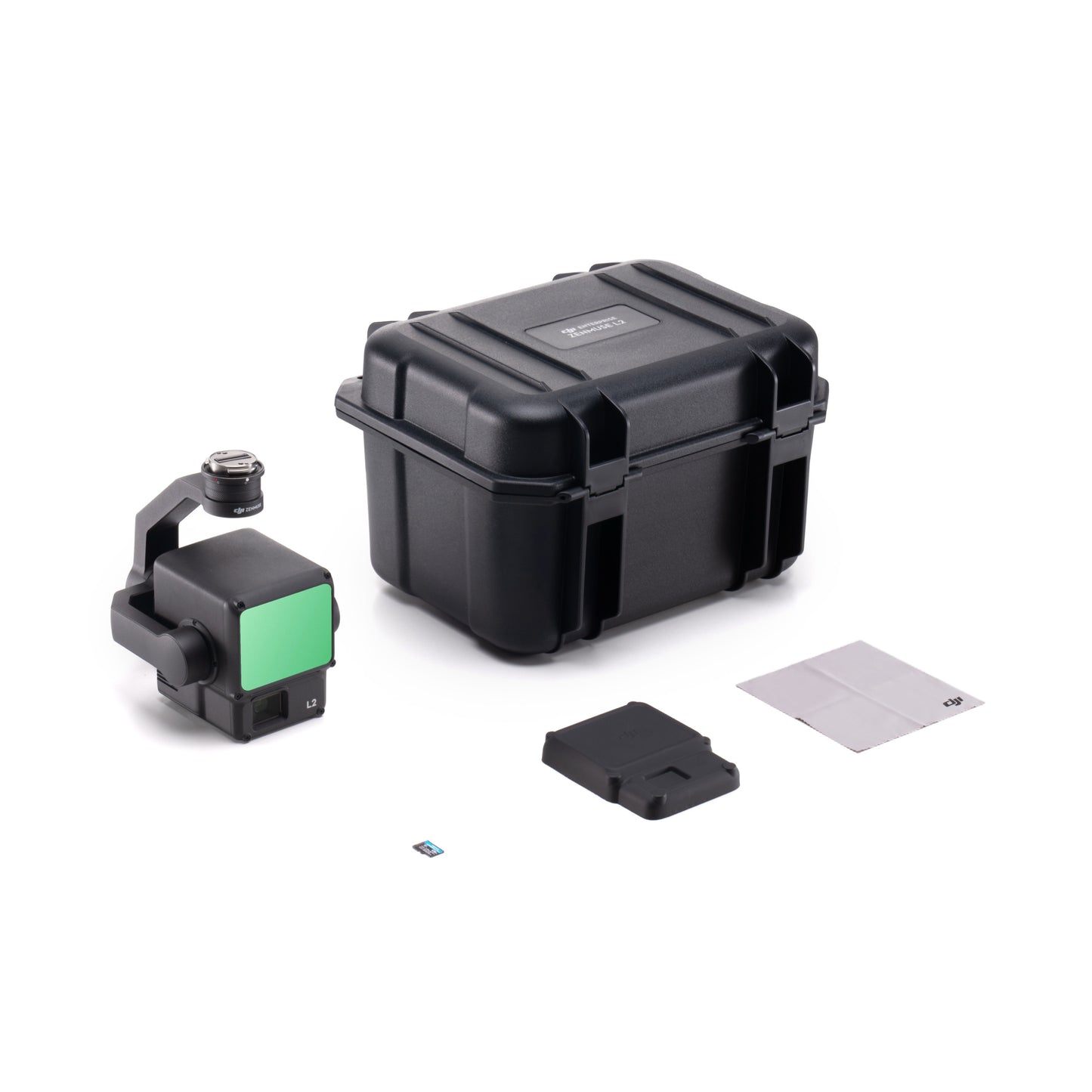
In the Box
- 1x DJI Zenmuse L2
- 1x MicroSD Card (128GB)
- 1x Lens Cap
- 1x Storage Case
- 1x Lens Cleaning Cloth
- 1x Dronefly Care Plus (Zenmuse L2)

